
A vacant lot can look ready for construction and still carry limits that affect a home’s design, budget, and schedule. Before you buy or build in Southwest Florida, a Florida residential site plan helps show what the property can realistically support. Local city or county rules may change those possibilities.
The drawing is more than a house placed on a parcel. It connects property lines, setbacks, elevations, drainage, utilities, flood conditions, access, and local requirements into one clear construction picture.
As a Florida homeowner’s early-review guide, this article encourages you to check applicable local site plan requirements before purchasing or starting residential construction.
Reading the plan early gives you time to address concerns before they become permit corrections or costly field changes.
Read the Plan Legend Before the Drawing
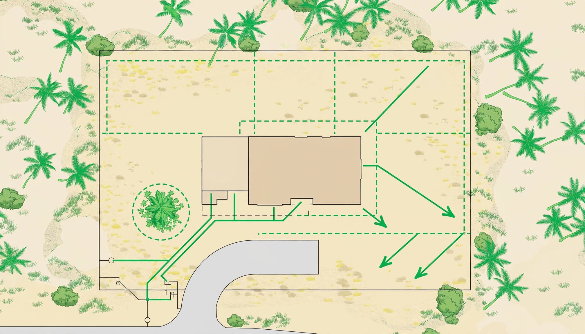
Start at the outside edges of the Florida residential site plan. First, compare the legend and drawing with local site plan requirements before interpreting individual features.
The legend explains the north arrow, scale, line types, abbreviations, and symbols. Identify markings for existing and proposed features, utilities, drainage, trees, easements, and flood information.
Confirm Property Lines, Easements, and Setbacks
Property lines define where your parcel ends. Setback lines show how far the home, pool, detached garage, or other accessory structures must stay from those boundaries.
Compare the boundary information with a current property survey. Then look for utility easements, drainage easements, canal maintenance areas, and rights-of-way. These areas may limit where you can build, add fill, plant trees, or place a fence.
In Lee County, site plan requirements include roof overhangs, the basic building outline, setbacks, driveway placement, septic systems where applicable, and recorded restrictions or other site constraints. A house footprint that appears to fit may not fit once roof overhangs and required clearances are included.
Review the Proposed Footprint and Access
The proposed structure should be easy to identify. Check its dimensions, building height, driveway location, walkways, patios, pool equipment, and detached structures. Confirm that each feature fits after boundary, setback, access, and easement limits are applied.
Pay close attention to the front of the lot. Driveway placement can depend on sight distance, drainage, sidewalks, culverts, and the utility layout. The driveway connection may also depend on the right of way that controls the road frontage. A county road, city street, or private road may require a different driveway approval.
For a new build, construction planning, design, and zoning approvals should begin before finalizing the floor plan. The lot must support the home, not the other way around.
A Site Plan Is Not the Same as a Property Survey
A permit site plan shows proposed work in relation to the parcel. A formal property survey documents existing property conditions and is prepared by a licensed land surveyor.
A topographic survey may document existing elevations, contours, drainage patterns, and other site conditions. These documents answer different questions from a proposed site plan. Parcel data, GIS records, and aerial imagery shouldn’t replace a survey when certification is required. Local site plan requirements may also include certified boundary, elevation, or coastal information.
Cape Coral’s residential review guidance requires a sealed property survey that’s less than one year old, along with drainage details, protected-tree information where applicable, and signed, sealed drawings from the architect or engineer of record. Review the city’s residential plan-review guide before relying on an older survey. Verify the survey’s age, seal, scope, and acceptance with the applicable permitting office.
If boundary, easement, elevation, or coastal information is unclear, obtain a current survey and resolve those issues before permit review.
Read Grading and Drainage Information Carefully
Water is one of the first issues reviewers study in Southwest Florida. Flat lots, seasonal high groundwater, canals, heavy rain, and coastal conditions make lot grading important, even when elevation changes are small.
Follow the Direction of Stormwater Runoff
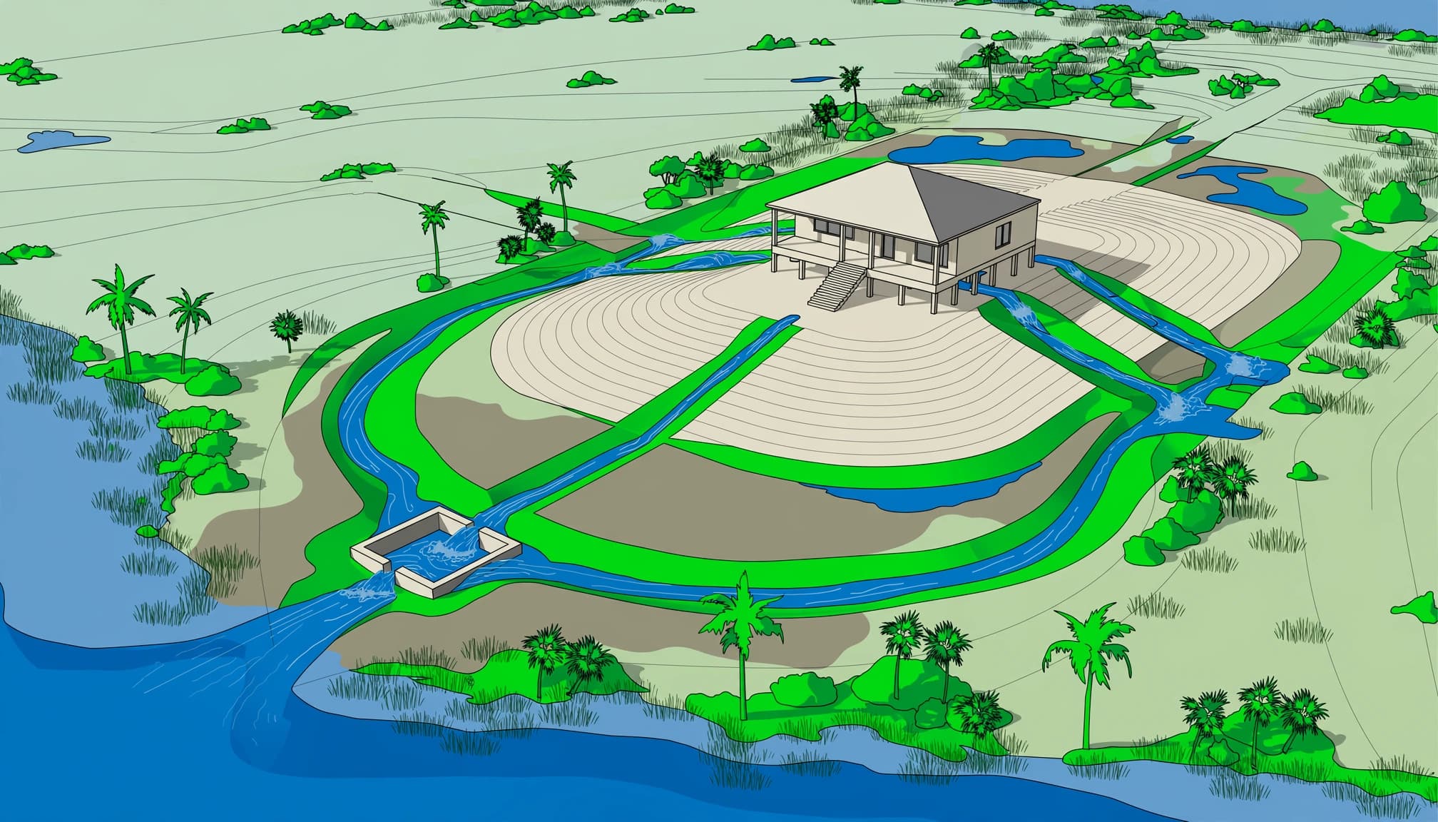
Look for arrows, spot elevations, swales, drains, inlets, catch basins, and discharge points. Together, these features show how rainwater should move across the property.
The drainage plan should show how stormwater runoff from the roof, driveway, and yard reaches a lawful receiving area. That may include an approved swale, drainage system, retention feature, or other discharge point.
Roofs, driveways, patios, and pool decks add impervious area and can change drainage calculations. During construction, temporary controls can also help prevent soil erosion on exposed grades.
The plan should avoid sending additional stormwater toward a neighboring lot. It should show a clear path to an approved receiving area.
Drainage problems often begin with a few inches of grade change, not a dramatic slope.
Check Finished Floor and Ground Elevations
Compare existing and proposed lot grading around the home, driveway, and yard. This helps you understand where water will collect, flow, or require additional drainage features.
Elevation callouts show how the proposed home relates to existing grade and surrounding land. A raised finished floor may affect stairs, driveway slope, accessibility, utilities, landscaping, and foundation design.
The City of Fort Myers requires drainage maps to show existing and proposed flow paths, swales, pipes, inlets, outfalls, receiving water, and elevations extending 40 feet into adjacent parcels. Its site-work checklist also calls for seasonal high water table information when drainage calculations are required. Confirm current local requirements before relying on this example.
Check Flood Zones and Base Flood Elevation
A FEMA map designation is important, but it is not the full answer. The building department and floodplain administrator confirm the current flood zones and parcel-specific requirements.
Understand What the Map Information Means
A Special Flood Hazard Area can affect design elevation, foundation type, utilities, fill, flood openings, and documentation. These flood-related site plan requirements may be part of the local review. The base flood elevation, often called BFE, is a mapped floodwater elevation used in design review.
Zone X is generally outside the Special Flood Hazard Area, but it doesn’t mean the lot cannot flood. Drainage, rain events, canals, storm surge, and site elevation still deserve attention.
Lee County provides parcel-specific flood-zone and BFE resources through its floodplain building information. Confirm the current parcel designation and flood zones with the floodplain administrator. Check the design against the applicable base flood elevation, not a real-estate listing or outdated map.
Coastal and Floodway Conditions Need More Detail
Zone VE is a coastal high-hazard area subject to wave action. These properties may require an engineered open or deep foundation system, often with piles, piers, or columns. Structural fill isn’t a simple substitute for proper coastal design.
Lee County requires a No-Rise or No-Impact Certification for work in a regulatory Floodway. The certification must be prepared, signed, and sealed by the appropriate Florida-licensed professional engineer before submission with the site plan.
Barrier-island and coastal-zone projects may also require a certified survey identifying the coastal construction zone, flood-zone requirement, and existing grade elevation. Verify the current map, floodway status, and local floodplain requirements with the city or county before approving construction plans.
Look Beyond the House Footprint
The building outline is only one part of the approval process. Review the full site, including environmental limits, utilities, drainage, and accessory improvements.
Wetlands protection, wetland buffers, and related environmental restrictions may limit clearing, fill, drainage changes, or construction locations. Verify the applicable local and state review before assuming the parcel is unrestricted.
Protected canopy trees may need to remain in place, receive protective barriers, or follow local removal and replacement rules. Landscape requirements may also address tree replacement, plant placement, and local planting rules. Florida friendly landscaping can support choices suited to Southwest Florida conditions.
A canopy tree that conflicts with the driveway, pool, addition, or septic area can change the site layout. For homes without public sewer, the plan should show the septic tank and drainfield. Well location, utility routes, generator placement, air-conditioning equipment, irrigation systems, fences, retaining walls, and pool features may require their own spacing and review. Florida friendly landscaping may also reduce irrigation demand and drainage conflicts. Review these features together before construction or an addition is designed.
This matters for additions too. Home additions and remodeling services often require a new site plan because the existing building envelope may have little room left.
Know When Professional Seals Are Required
Not every residential plan needs the same professional involvement. The required documents depend on the project scope, location, flood conditions, and local rules. Before applying for building permits, verify the complete submittal with the applicable Florida city or county.
Situations That Commonly Require Added Review
A licensed surveyor may be needed for certified boundary or elevation information. A structural engineer may be needed for elevated foundations, unusual loads, retaining structures, pilings, or flood-related design.
Architectural or engineering seals may also be required for coastal projects, site-work plans, drainage systems, or local plan-review packages. Sealed drainage or structural documents may be required, along with professional engineer review, depending on the site. Don’t assume an online sketch meets the standard for a waterfront, flood-prone, or complex lot.
Compare Local Requirements Before Filing
The Florida Building Code provides the statewide baseline. Cities and counties administer additional zoning regulations, floodplain review, drainage, land-use, right-of-way work, fees, electronic submittals, inspections, and permit-related notes. Compare your project with local site plan requirements before filing.
| Jurisdiction | Example of Local Site Review Detail |
|---|---|
| Lee County | Plot plans must address setbacks, easements, driveway placement, septic information where applicable, and canopy trees or other landscape requirements. |
| Fort Myers | Drainage mapping can extend into adjacent parcels and include seasonal groundwater data. A drainage plan may also be required. |
| Cape Coral | Residential reviews can require a current sealed property survey, drainage information, tree protection details, and sealed drawings. |
Local requirements may apply even when the statewide code is satisfied. Electronic filing makes document delivery easier, but it doesn’t cure missing information or guarantee permit approval.
Key Takeaways Before Permit Submission
Read the site plan as a property decision, not just a drawing set. Confirm the site plan legend and governing jurisdiction first. Then compare the proposed footprint with property lines, setbacks, easements, driveway access, utilities, lot grading, drainage, flood information, septic or well features, local requirements, and canopy trees. Confirm planting, irrigation, tree constraints, and Florida friendly landscaping decisions before construction begins.
Keep the supporting documents together before applying for building permits. Include the survey, elevation certificate when applicable, flood information, engineering documents, drainage calculations, correction notices, approved plans, and inspection records.
Resolve questions about fill, foundation and finished-floor elevation, stormwater runoff, coastal exposure, and protected trees before finalizing the floor plan. Resolving conflicts early supports permit approval and avoids costly corrections that can affect appearance, access, budget, and construction timing.
Frequently Asked Questions
Does Every Florida Residential Site Plan Need an Engineer’s Seal?
No. Requirements vary by city, county, site conditions, and project scope. Cape Coral requires sealed drawings for its residential plan-review package, while Lee County requires sealed engineering for certain floodway certifications and coastal work.
Confirm the requirement with the local building and floodplain offices before submitting plans.
Why Do Site Plans Get Rejected?
Common issues include missing setbacks, unclear property lines, outdated surveys, incomplete drainage information, unapproved driveway locations, missing flood elevations, absent professional seals, and conflicts with easements or protected trees.
A complete plan must satisfy both building requirements and local technical rules. A clean drawing cannot overcome missing site information.
Can an Online Permit Portal Approve Plans Automatically?
No. Florida permits are filed electronically, but each application still receives local review. The correct portal depends on the property’s jurisdiction, and missing documents can delay approval.
For common questions about permitting, licensing, and project responsibility, review our construction permitting FAQs.
Build With Clear Site Information
The strongest construction plans begin with a clear reading of the land. Property lines, drainage, flood elevation, access, and local review requirements shape the home long before framing begins.
A well-prepared Florida residential site plan protects your budget, supports permit approval, and helps prevent expensive revisions after work starts. Before residential construction, additions, grading, drainage work, or permit filing, confirm current requirements with the applicable Florida city or county.
This article provides general information for Florida homeowners and doesn’t replace advice from the applicable permitting official, architect, licensed land surveyor, or professional engineer.
For support with a new build, addition, or site-specific construction question in Southwest Florida, Get In Touch.